 Perhaps you read about our
plan to conquer Iceland by fatbike? Perhaps you donated to the MNDA, or wished
us well before we left? Certainly I made enough noise about the trip in an
effort to drum up charity sponsorship.
Perhaps you read about our
plan to conquer Iceland by fatbike? Perhaps you donated to the MNDA, or wished
us well before we left? Certainly I made enough noise about the trip in an
effort to drum up charity sponsorship.
We had such grand designs,
we had plans, we had the gear and the desire. Sadly, we did not have all of the
luck. As a result, our trip didn’t quite go according to plan. Though that’s
not necessarily a bad thing.
Our original intention, that's Jim and me, was to jump on a bus in Reykjavik and head as far north as we could manage, then ride from the northernmost point (Rifstangi) to the southernmost point (Kotulangi) via the interior highlands (the Spengisandur). A journey of about 600km on gravel tracks and dirt roads, with river crossings and the barren desolation of pure wilderness. That was The Plan.
Our original intention, that's Jim and me, was to jump on a bus in Reykjavik and head as far north as we could manage, then ride from the northernmost point (Rifstangi) to the southernmost point (Kotulangi) via the interior highlands (the Spengisandur). A journey of about 600km on gravel tracks and dirt roads, with river crossings and the barren desolation of pure wilderness. That was The Plan.
Unfortunately Iceland has
just been through one of the hardest winters and the coldest June on record. As
a result, parts of our route were still under snow, and many of the river
crossings (difficult at the best of times) were impassable by bike. After
hearing all of this when we arrived, we elected that we’d start in Reykjavik that day, and
try to loop our way around the Hofsjokull glacier via the Kjolur route, joining
the Sprengisandur below the worst of the trouble. Plan B was a similar difficulty to Plan A but a little longer. However it avoided many of the blocked and dangerous areas. We reckoned that the extra distance could be covered by the time saving of not spending the first 24hrs heading north on a bus.

Plan A and Plan B
Initially Plan B seemed
like a good one. We set off from Reykjavik on the afternoon of the 16th July
2015, having first topped up our frugal supplies with salami and jelly sweets
at a Bonus Pig. Here began my fixation with jelly-sweets. A day without jelly
sweets was a bad day. To those who are thinking of creating your own Trail Mix
with a balance of sweets, chocolate, nuts and dried fruit; forget it. We did
that, and portioned it neatly for each day. The net result was that halfway
through the day all I had left to snack on was the nuts. Top tip: don’t scrimp
on the good stuff.


Reykjavik and the Bonus Pig
We rode out of town via a
couple of parks and along river paths, it was sunny and peaceful and we were
feeling fit. After a brief, and not wholly pleasant, stint on the ring road, we
took the Nesjavallavegur road (no.435) east, with the aim of reaching Þingvellir
(ancient seat of Viking parliament) 60km away to camp for the night.
Unfortunately, without initially noticing, the road we’d taken was one which
contained “many steep hills over 15%”, so by the time we arrived at Þingvellir
at 9:30pm, we were completely done in. After an exceptionally cold shower and a
bowl of instant noodles, and having been on the road in one way or another for
15hrs, we passed out.

The road from Reykjavik to
Þingvellir was not flat.
Day 2 dawned fresh and
bright, and after an utterly vile breakfast of instant porridge we were ready
to hit the road. Our aim was to finish the tarmac section that day at the
Gulfoss waterfall and along the way take in Geysir (big hot water spout which
gives it’s name to all of the geysers of the world). The route was a good
reminder of how dreadfully inefficient mountain bikes are on tarmac. We rumbled
along expending vast amounts of energy in noise and friction and presenting a
huge frontal area to a freshening headwind. A significant highlight was
stopping for lunch at the Geysir cafe and trying their beef balls. If there is
a more dense substance in the universe I’d be amazed. These things bent light
towards them. Eating one was like trying to slice through an anvil with a
flip-flop, and for the next 10km I had a stomach like a wet bin-bag with a
couple of bowling balls in it.


Beef balls
and a bit of product placement
The Waterfall at Gulfoss is undeniably beautiful. I’d been there
about 10 years before with my wife, and I recalled a small carpark, a fairly
ramshackle little gift store and little else. How times have changed. Every few
minutes a huge coach arrived to disgorge punters onto a wooden boardwalk,
taking them on pre-determined route to a viewing platform. The shop, which many
years ago seemed to sell a few postcards, the inevitable stuffed Puffin toy,
and a few CDs of Bjork, Sigur Ros and some hippy whale music (really, it did);
was now at the forefront of naff Icelandic marketing.

Gulfoss - Noisy
Of course this is to be expected, after all we were on the most
popular tourist circuit in the country (the Golden Circle), and just because we
got there by bike, doesn’t mean we weren’t tourists too! But the sheer weight
of visitors was astounding to me. Faced with this, I think the authorities have
done a decent job of keeping everyone in one place and ‘off the grass’.
After being buffeted by passing tourist coaches for the 10km between
Geysir and Gulfoss, it was a pleasant relief to head north-east out of the
carpark and away from the traffic. It seems that for about 90% of visitors,
Gulfoss is the end of the road. For us though, it represented the start of the
proper ride.
We spent the second night in an empty tin hut 10km north of
Gulfoss on a spit of land between two glacial streams. The setting was
absolutely idyllic, with a glorious vista which included the Langjokull glacier
and the snow-capped Blafell Mountain. Out of the wind, with the sun shining I
sat on a grassy tussock and read my book; completely content. The hut was
pretty basic, made from rusting corrugated iron and a couple of windows which
looked like they’d been stolen from different buildings. The inside of the hut was
festooned with cheerful graffiti from previous occupants. The most notable was
from a guy who’d ridden across central Iceland on a Brompton (nutter).
Inevitably, dinner was instant noodles.


The hut and it’s views
On the morning of the third day (after gagging down a small
mountain of porridge) in brilliant sunshine we left the tarmac behind. The wind
was still rising, having reached a steady 30-40kph at this point, and forward
motion was becoming more and more difficult. As we crept over a 700m pass, the
huge open plateau of the Kjolur lay before us. Our destination was still 70km
north, the road was loose and gravelly and the wind was kicking up dust-storms
far ahead across the desert. With dust goggles on and through gritted teeth, we
battled into the wind, and then the rain, occasionally being passed by 4x4s and
the odd off-road bus full of happily waving tourists (one group got out to
cheer us up a hill, which was quite cool).
Incongruously, about halfway across the Kjolur, there’s a small
shop selling a few dry goods, beer, knitwear, coffee and toasted sandwiches. We
stopped here to warm up and get some hot food. At the same time we watched as a
cyclist approached a river crossing and meticulously removed every last item from
his bike before going backwards and forwards scores of times with his gear. It
all looked very labour intensive, and not at all how I’d have imagined doing it
myself. As he neared the end of his ordeal, the lady running the shop dashed
outside to show him a shallow easy route about 5m downstream from where he was
crossing. I wouldn’t like to say if she’d only just noticed, or spent some time
bathing in schadenfreude first.

The Kjolur in lowering cloud
Before we left, the shop keeper gave us a few dubious looks and
issued a couple of dire warnings about the weather getting worse for the coming
days. It was pretty clear she thought we were going the wrong way, and having
spent the better part of half a day going 40km, it was hard to disagree. Nevertheless,
we put our soggy waterproofs and gloves back on, and stomped outside into the
teeth of a gale.
Only a couple of kilometers past the shop we met a cyclist
coming the opposite way. Like most people, he immediately took an interest in
my fatbike; squeezing the tyres and nodding wisely. Only unlike most people
though, this guy was just a bit of a jerk. Unprompted he informed us that he
was in part responsible for making my bike ‘famous’ by
setting a some kind of a record on it. In fairness to him, that is fairly
awesome, but as an opening statement to a couple of total strangers it’s a bit like saying “I’m really very very wealthy you know?”.
When we conversationally mentioned that conditions were pretty
tough, he proceeded to tell us he’d been in Iceland for months and knew
“never to ride north”. He then told me that I can’t have used my bike much, as
there was so much tread on the tyres and his fatbike tyres were practically
bald (we took his word on that). Maybe it was unintentional, but the impression we were left
with was of a man who was determined to be that much tougher, more
knowledgeable and generally cooler than everyone else he met. Perhaps in other
circumstances he’s a great guy, but on this particular day I think his charm
gland was misfiring. Interestingly, at the end of that day we were chatting to
a Dutch cyclist who was telling us about this really annoying cyclist
he’d met earlier that day...
Having politely disengaged from our super-impressive new friend,
we set off north again. Our average pace was little more than 6-8kph, and on the poor surface we’d reached the point of pushing on the steeper sections. We were
wearing every stitch of clothing we had, our faces covered with buffs, hoods up
and pulled tight, but if we stopped for more than a minute or two we started to
get cold very quickly.

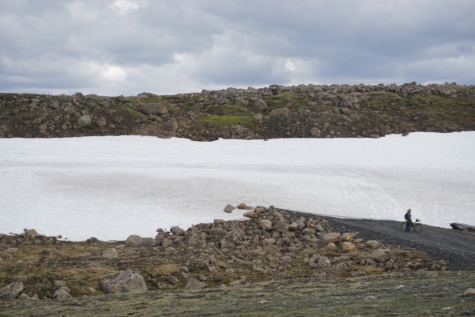
Kjolur - Nothing to see here
After about 60km we climbed into the cloud, and the already
lifeless grey and brown scenery disappeared into a white veil of nothingness.
Even the 4x4s and busses seemed to have stopped passing us, presumably turning
off for Kerlingarfjoll 10km earlier. There was just us, a 500m visible ring of
dust and gravel and the roaring of the wind through our hoods. We stopped
joking, then talking, then we stopped communicating entirely. Each slipping
into his own thoughts and getting on with the business of turning the pedals
and moving painfully forward. It was a very hard day, but after nearly 13hrs of
cycling over 80km we made it to Hveravellir, and the soothing warmth of its
geothermal pool.

Hveravellir – Geothermal vents
That night the wind rose further still, efficiently dismantling the odd tent and leaving the occupants to scurry around chasing their belongings and
getting cold and wet. Our intention for the following day was to continue
heading north for 30km, before tracking north-east over a mountain pass to a
hut for the night, and eventually (about 2 days later) joining the Sprengisandur
as originally planned. We knew we’d have to make good progress to do this in
the time we had, but when we set off from Reykjavik in the sunshine, it seemed
doable. Now, with the wind some way upwards of 70kph and increasing flurries of
snow, we could barely climb onto our heavy bikes, let alone make the distances
we needed. What’s more, we’d been told that the mountain pass was still under
snow (how much we didn’t know). The final straw was when Jim was blown off his
bike after we'd made about two fairly horrible kilometres in half an hour.
There was no way we could manage Plan B with the time we had.
So, reluctantly, we changed our plans (again).
Halfway along the Kjolur to the east is the Kerlingarfjoll
mountain area. This would have been another option to join the Sprengisandur,
however this too was under several metres of snow and closed. So, sadly, our
only choice was to turn tail and ride the 90km back to Gulfoss and the only
other viable river crossing heading east. Still, at least this time we had a
tail wind, and what took us 13hrs the previous day took only 7hrs with the
wind. We found a campsite halfway between Geysir and Gulfoss, then found it
made excellent pizza. We spent that evening eating (not noodles!) and working
out what to do next.


Crossing the Kjolur isn’t easy
My lasting memory of the Kjolur, and from what I’ve heard this is
true to some extent of the Spengisandur too, was surprise at how heavily
travelled it was. While it was undeniably beautiful, and we only saw two other
cyclists; there were many 4x4s and buses along the route. So in spite of the
emptiness and desolation, it rarely felt like the wilderness. We knew that if
something happened, there would be someone along in half an hour who could
help. It’s not at all what I had expected.

The Kjolur – Looking back at where we’d come from (about twice as
far as the faint peak in the centre)
After riding across the Kjolur twice in as many days, Day 5 was
going to be a ‘rest’ day. We had looked at the maps and found a track running
45km east/west from Gulfoss over an 800m shoulder to Haifoss (another huge
waterfall) where there was hut and campsite. The route had quite a few river
crossings, but from our vantage point and the overall topography it didn’t look
like it was being fed by the local glaciers, so we maintained hope for low
levels of water.
The day started out well enough; we had noodle for breakfast (anything is better than porridge), the sun was shining, the wind had
dropped a little and the views were epic. We rode slowly upwards on the
opposite side of the river to the flocks of tourists visiting Gulfoss, and then
swung east over the mountains.


Views from the non-tourist side of Gulfoss
That’s when the fun started.
The track was in a shocking state and clearly not at all
well-travelled. We couldn’t help wonder if that was anything to do with the
‘large’ crossing over the Fossá river towards the end of the route. We found
ourselves trying (and frequently failing) to cycle on loose rocks the size of
tennis balls, the track generally meandering east and uphill over countless
blind summits. Every uphill section meant Jim getting off to push, while my
fatbike came into its own by just about managing to stay rideable. This at least
made me happy, as it meant the smug German fatbike expert from a couple of days
before was incorrect when he'd said I was on the wrong bike. The pace was glacial.
We crossed four or five small rivers, a couple requiring us to
strip down to our underwear and grit our teeth as the freezing water rushed
around our legs. Here the fatbike became a serious hindrance. It floats. Even
with all of the baggage it floats. This meant that any water deeper than about
0.5m caused the bike to tip sideways and try to launch itself downstream.
Crossing the rivers became an act of clinging to the handlebars and trying to
stop the thing from washing away.

This is considerably less fun than it looks
This continued for the next 5hrs. With crossings and loose uphills
rapidly sapping our strength and our will. And all the while the nagging
question of why we hadn’t seen another vehicle of any kind. Was is because of
the Fossá crossing? Was it going to be too deep or fast? Fatigue and nerves
were beginning to prey on us, when we encountered at least one of the reasons
why there were no vehicles.
We rounded a corner to find a snow drift across the track. It was
about 15m high, several hundred metres wide and completely blocking the way. On
foot and pushing the bikes, it wasn’t too hard to get around, but only a
lunatic would have tried to drive over or around it.
Okay then…
Eventually, and after yet more small river crossings and uphill
sections, we came to a long loose downhill with the Fossá forming a ribbon of
water glinting in the distance. Neither of us had much energy left at this
point, and we were hoping against hope that we could cross. The thought of
dragging our bikes back up the mountain was not one we were looking forward to.
With not many other options, we headed down to the river. As we
approached it got wider and louder. When we finally stood on the bank, looking
into the rushing torrent of fast flowing water, both of us were more than a
little nervous; just a few hundred metres downstream the river ran through a
series of small rapids before plunging 120m over the Haifoss waterfall.

I may or may not be making an obscene gesture
With no choice but to either quit or go for it, Jim made the
crossing first. The water rose to thigh height, and for a moment he looked at a
loss, before finding a technique of using his bike as a prop and slowly
hobbling across. I knew this wouldn’t work for me, Jim’s bike didn’t float. My
crossing was more eventful; with no means of propping myself up, and the bike
being dragged down river, I had to use it like a sea anchor to steady myself as
I crossed. Jim came back over to help, but the bloody-minded part of me
declined, determined to make it on my own. One slip and that was it, the bike
and all of my gear was gone and I was stranded miles from anything resembling
help, on a road no-one used. Fortunately there were no slips, and with
adrenaline pumping we made it to the opposite shore unscathed. All that
remained of the day was to take in the magnificence of Haifoss, then pedal
another 5km downhill and downwind to set up camp.

Haifoss – 120m straight down. Our river crossing is just beyond
the horizon.
Unfortunately the hut had been invaded by a team of Icelandic
rednecks. When we arrived they were already completely drunk out of their minds
and just setting up for an evening of getting even more drunk. The scene in
front of us was this: Two guys with beers (for the duration of this anecdote
just assume everyone is doing everything one handed because the other hand is
already occupied with beer) were outside lighting a barbeque with petrol. One
guy had set off the alarm in his truck and was trying to crawl through the boot
to shut it off, only he’d forgotten the key and was a bit stuck due to only
having one hand free. Two more guys were unloading crate after crate of beer
from another truck, and there was the owner of the hut stood watching the whole
thing and shouting a lot. Oh, and crotch-obsessed dog.
They were all very cheerful and friendly and wanted us to stay
(especially the dog), but after 12hrs of hard riding, this did not seem like a
place where we were going to get any rest. So with heavy hearts, and the slight
sadness that comes from missing out on an epic party, we got back on our bikes
and rode another 30km to a quiet campsite infested with midges. I think we lost
the plot that evening. We didn’t need a campsite, we didn’t need to ride 30km
more and we ended up heading in the wrong direction for Landmannalaugar. If I
have any regrets from the trip, it’s that we should have crossed the Þjórsá at
the hydro plant 3km south of the hick-hut and wild-camped close to the F225 to
Landmannalaugar. But we were tired, strung out and fed up with the headwind.
In retrospect I’d hesitate to say that day was definitely the best
part of the trip (mainly because of the poor choice at the end). But it was
exactly the kind of experience I’d been looking for. It was hard, a bit scary
and utterly unsupported. We felt like we’d found a little of the the wilderness
we’d been looking for, faced the challenges it presented and arrived at the
other side not found wanting. That’s not to compare what we did to climbing
Everest or other equally impressive adventures; but it’s all about perspective.
To us, this was what the spirit of the trip was about, and I doubt we’d have
found it if we’d followed Plan A.
The following day we rode the 70km to Selfoss for provisions and
to work out the best way to Landmannalaugar following our wrong turn the
previous evening. This ended up being the bus. With only 70km covered on easy
roads, day 6 turned out to be the rest day. We arrived at Landmannalaugar quite late; the bus driver having had a whale of a time getting through river
crossings and snow to reach the camp site. But when the sun only sets for 2 hrs
a day, and it doesn’t really get dark, arriving late isn’t an issue.

Landmannalaugar
After pitching the tent we immediately stripped the bikes of gear
and went for a ride up the valley, revelling in the lightness of the bikes
beneath us. The valley floor was a huge gravel outwash plain bisected by
hundreds of tiny streams. On all sides the rounded hills rose in a combination
of orange, ochre, green and red; with steaming horned black volcanic extrusions
thrusting through the mountainsides and disfiguring the landscape. At any
moment I expected to hear a deep rumble and see lava (or Orcs) spewing from the
mountaintops.

Landmannalaugar – The briefest of sunsets
As we explored it became clear that the campsite sits at the head
of a massive historic lava field which has blocked a valley almost completely.
Only by walking over the lava field can you find a hidden verdant green plain
surrounded by steep sided mountains capped by snow. As we sat and stared at
this incredible, almost impossible sight, for the first time in a week the wind
disappeared and we were confronted with near perfect stillness. The only moving
thing was a waterfall cascading down the mountainside a few km in front of us,
and the only sound was its faint muffled roar. It was utterly tranquil.

Landmannalaugar
The following morning (day 7) was bright and clear, an experience dulled
only by porridge ming. We decided to make our way along the Fjallabaksleið
Nyrðri road (F208) towards Hólaskjól. This was a relatively short day of 45km,
but we were beginning to suffer at this point and we knew that the route had
quite a few river crossings and a couple of stiff climbs. The map showed five
rivers, which in true Icelandic style turned out to be about 12. Fortunately
the first and last (the largest) were bridged.
The F208 road winds its way through the northern foothills of the
Mýrdalsjökull glacier. The road is stunning, showcasing the volcanic and
tectonic activity which has shaped the region, and the almighty glaciers which
continue to carve their way through the landscape.
Unfortunately, after a number of tedious fords, impatience got the
better of me after the fourth or fifth river crossing. Rather than stopping, prodding
about, changing my shoes etc, I just started going at them full tilt on my
bike. While this was certainly effective and no doubt spectacular, it did lead
to incredibly cold and wet feet for the next 8hrs. To all future travellers in
the region, I would advise taking a different course of action.
The final descent from the mountains led to the Eldgja River and
the Hólaskjól campsite. This was vastly enlivened by racing a bunch of
Brazilian guys on a supported motorbike tour down the mountain and across the
fords. Here my gung-ho river crossing technique and Jim’s inability to locate
his brake levers worked to our advantage, and we won. There was much grumbling
from our petrol powered friends. Grumbling further enhanced when we skipped
across a footbridge and sat on a small bench watching them one-by-one nearly
drown crossing the last river, while we scored them out of ten for effort and
aggression.

Fjallabaksleið Nyrðri – Stunning landscapes
Another night of dining on noodles led to our final day (of
porridge) and an attempt to hit the southernmost point (Kotulangi). This is
located about 2km south of a massive lump of rock on the south coast called Hjörleifshöfði. The day was going
to be a big one; with 35km of gravel road, followed by a 45km dash along the
ring road (imaginatively entitled ‘1’) then 4km across a black sand beach.
Followed by the reverse along the beach and a further 12km to Vik, whereupon we
would collapse, burn our bikes and find some beer.


Provisions may have been running low, but the scenery and riding
was still epic
While uneventful, the day proved to be hard. We were flagging
pretty badly by the time we got to the ring road, overall fatigue from the
previous days was making itself known. After the solitude and silence of the
wilderness, there are few sights more depressing than a strip of tarmac
frequented by scores of tourist buses. This was compounded by a lump of rock
(Hjörleifshöfði) which appeared to be moving away from us as fast we were
moving forward. I’d sort of given up hope that the end of the trip would be
anything but an overwhelming disappointment, until we left the ring road and
started across the beach. Once again we were alone in a bleak and deserted
world. Our tyres crunching along the beach as we aimed for a mirage of the sea
shimmering above the bone dry black sand.


All beaches are special in one way or another, but Kotulangi
really does feel like the very end of the world. Cut off from the road by sand
impassable to anything but a big 4x4 or bikes (too far to walk for all but the
most inquisitive) and stretching seemingly endlessly in all directions, it was
a fitting place to end our adventure.
We sat on the warm dark beach, watching the sun on the waves,
listening to the sea and drinking the last of our coffee.
Eventually we roused ourselves and made our bedraggled way to Vik.
We’d covered about 650km in 8 days, taken routes we’d never heard of, and had
an epic adventure… Not quite as planned, but then there’s something to be said
for leaving your plans behind in a place like Iceland.


Tom
Vincent
04/08/15
My father enjoyed the day trips from new york. I told him Haifoss's name, and after hearing this name, I decided to go there and have the best time there.
ReplyDelete